Features of Surface Seismic Soundings
- Sometimes referred to as MASW, but Sitka’s performance is significantly more elaborate
- Vs and Vp profiling for seismic site classification (Vs30), without a borehole
- Entirely from surface, non-invasive, risk free, no permitting required
- 2D Profile up to 60m in depth, but most reliably to 40m
- Bedrock Depth Profiling included
- Applicable to Ground Stiffness Evaluations, Slope Stability Analysis, Soil Liquefaction Studies
- Delineation of “soft zones”, potential voids, other anomaly detection
- Elastic Modulus: Poisson’s Ratio, Shear, Young’s, and Bulk Moduli
The Survey
- Often called MASW, but this is a significant understatement to the methodology which Sitka performs
- 7 geophysical methods used in one survey:
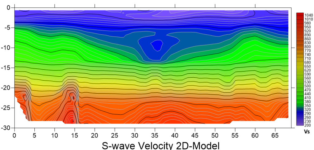
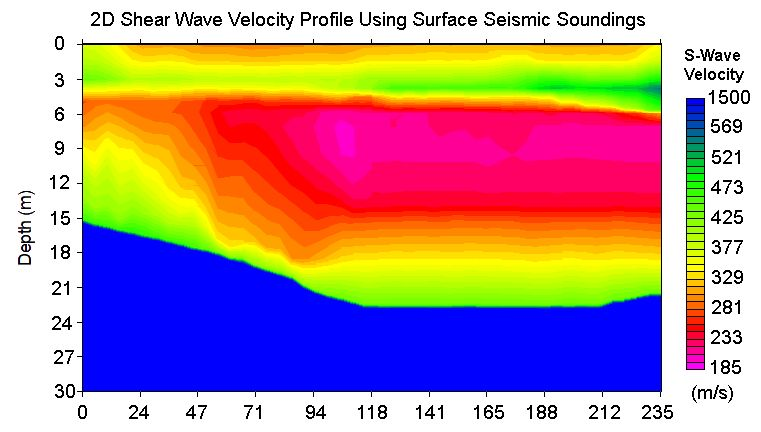
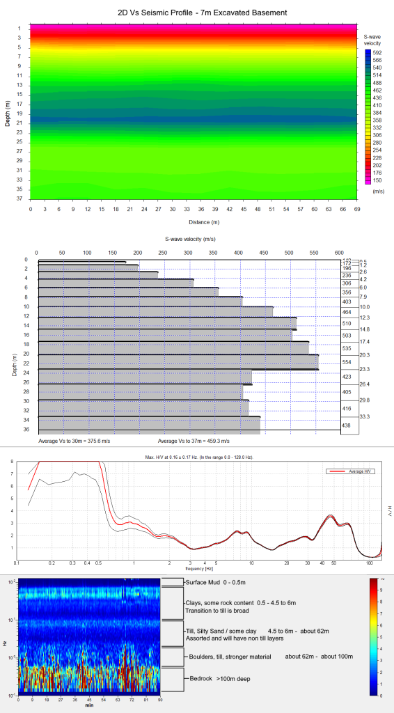
2D MASW – 2D Profile of Vs shear wave velocities for the upper 30-60m
MAM – Passive for collecting deeper features of Vs
2D SRT – 2D Profile of Vp compressional wave velocities for rock and water table features
HVSR – Excellent corroborating data for confirming bedrock and other stiff layers
ARI – Acoustic Resonance Imaging which generates 2D profiles of overburden layers, especially effective
Seismic Reflection – Additional 2D profile of overburden, rock fractures, weathering and bedrock
EFWI – A computer processing algorithm used to clarify data sets and profiling imagery - While a 1D result will always be included, a 2D profile of the site will most completely capture seismic data.
Advantages
- SPT and CPT always must use a conservative value for Seismic Site Class – so the lowest value on the span of values which encompass a site class letter. A Site Class D, determined by SPT and CPT will be 180m/s. Using geophysical methods, like Surface Seismic Soundings, the Vs30 of a site will always be higher, even if the site class is a D. From a structural engineers perspective, the difference between a 180m/s Vs30 versus a 240m/s Vs30 is significant. The cost saving for the end client can be incredibly large
- Surface Seismic Soundings will never encounter refusal conditions, permitting, unsafe conditions, or risk factors for cost.
- Structural Engineers now consider Vs, and not the base letter classification to be the pertinent factor when designing structural elements. These Surface Seismic Soundings satisfy these Vs requirements at a very reasonable rate. Typically $3,000 before taxes if within the Lower Mainland of BC
Comparison of 2D MASW/Surface Seismic Soundings Against SPT, CPT, DCPT & SCPT
| Criterion | Surface | Invasive Drilling Methods |
|---|---|---|
| Data Continuity & Resolution | High (continuous velocity profile) | Low (discrete point data) |
| Site Disturbance | None | Moderate, drilling |
| Spatial Representativeness Depth of Measurement | up to 60m in depth, but typically 30-40m. Across a 69m spread. | Limited to single-point measurements No limit of depth, but point based. SCPT risks refusal conditions which are costly. |
| Cost | Lower, $3,000 typically, all in | Higher, about $7,000 for SCPT >$9,000 for Downhole |
| Safety and Accessibility | Very Safe (no heavy equipment required, not one injury or near-miss to date) | Less safe (rigs, deep access needed, hydraulics) |