Horizontal-to-Vertical Spectral Ratio (HVSR) Method in Near-Surface Geophysics
The Horizontal-to-Vertical Spectral Ratio (HVSR) technique represents a sophisticated passive seismic method that analyzes ambient noise vibrations to characterize site-specific resonance frequencies and estimate subsurface velocity structure. By measuring the spectral ratio between horizontal and vertical components of ground motion, the method identifies fundamental resonance frequencies caused by impedance contrasts between sediment layers and bedrock. This approach, grounded in seismic wave propagation theory, provides valuable insights into site amplification effects without requiring active seismic sources, making it particularly useful in urban environments or sensitive areas where traditional surveys may be impractical.
HVSR offers several distinct advantages for near-surface investigations. The method requires only a single three-component seismometer, enabling rapid, cost-effective site screening with minimal equipment. Its non-invasive nature allows deployment in developed areas where active-source methods face logistical constraints. In seismic microzonation studies, HVSR effectively maps spatial variations in sediment thickness and identifies potential amplification zones. When combined with MASW or other active methods, it provides complementary constraints on velocity-depth profiles, improving overall interpretation accuracy. Typical applications include preliminary site characterization for earthquake engineering, bedrock topography mapping, and identification of soft soil layers that may require more detailed investigation. The technique’s ability to operate using only ambient vibrations makes it uniquely suited for long-term monitoring of site response characteristics as well.
Technical Advantages and Practical Applications
From a technical perspective, HVSR analysis provides several key benefits for near-surface geophysics. The method’s sensitivity to fundamental resonance frequencies allows reliable estimation of sediment thickness when calibrated with known velocity information. Recent algorithmic advancements now enable extraction of not just dominant frequencies but also directional site responses and higher-mode vibrations, providing richer datasets for interpretation. In urban environments, HVSR proves particularly valuable for assessing local site effects that influence seismic building code requirements, as it can be deployed in tight spaces between existing structures. The technique also serves as an efficient screening tool for identifying sites that warrant more expensive active-source surveys, optimizing investigation budgets.
Practical applications of HVSR span multiple disciplines within near-surface geophysics. Earthquake engineers utilize HVSR results to develop site-specific response spectra and assess potential amplification of ground motions. Geotechnical professionals employ the method for rapid evaluation of soil stiffness profiles and detection of hidden paleo-topographic features. Environmental consultants find HVSR useful for mapping the base of unconsolidated sediments when investigating contaminant transport pathways. The method’s versatility extends to archaeological surveys, where it helps identify buried structures without ground disturbance. When integrated with other geophysical data, HVSR significantly enhances subsurface models while requiring minimal field time and equipment – a combination that makes it an indispensable tool in modern near-surface characterization projects.
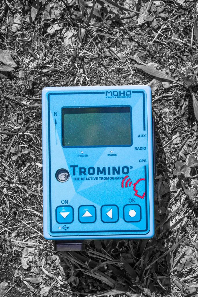
The Tromino by MoHo: Advancing Passive Seismic Acquisition Through Precision Engineering
The latest generation Tromino seismograph represents a significant technological evolution in passive seismic instrumentation, offering distinct advantages for HVSR surveys compared to conventional three-component systems. Its integrated design combines laboratory-grade MEMS accelerometers with 24-bit digitization which achieves an exceptional dynamic range (140 dB) and low noise floor (<1 ng/√Hz) that surpasses traditional geophone-based systems. The instrument’s proprietary firmware implements real-time signal processing with advanced anti-aliasing filters and automatic gain control, enabling reliable operation across the full spectral bandwidth required for both microtremor analysis (0.1-20 Hz) and structural monitoring applications. Unlike bulkier seismic stations requiring external power and data loggers, the Tromino’s self-contained design incorporates GPS synchronization, Wi-Fi connectivity, and 72-hour continuous recording capacity – features that significantly enhance field efficiency while maintaining research-grade data quality. The system’s embedded processing suite automatically calculates H/V spectral ratios with optional Nakamura or SESAME processing protocols, providing immediate QC capability in the field. For deeper investigations, the Tromino’s enhanced sensitivity at low frequencies (<0.5 Hz) permits reliable estimation of sediment thickness beyond 100 meters, a capability typically requiring much larger aperture arrays. These technical advancements position the Tromino as the preferred solution for engineers and geophysicists requiring both the operational flexibility of a lightweight system and the analytical precision of institutional-grade seismic equipment.
The Tromino by MoHo is a highly portable, three-component seismic sensor that excels in passive and active seismic surveys, complementing other geophysical methods by filling critical gaps in data resolution and acquisition efficiency. Unlike bulkier seismic equipment, the Tromino’s compact design allows for rapid deployment in challenging environments where most other equipment would be unable or limited to measure within. This enables high-density measurements that enhance the accuracy of shear-wave velocity (Vs) profiling and resonance frequency analysis. Its ability to record both ambient noise and active-source signals makes it particularly valuable for 3D bedrock refraction and Multichannel Analysis of Surface Waves (MASW) surveys, where dense spatial sampling is essential for resolving complex subsurface structures. When integrated with techniques such as electrical resistivity tomography (ERT) or ground-penetrating radar (GPR), the Tromino provides essential seismic constraints that improve subsurface characterization, particularly for near-surface applications like site response studies, liquefaction potential assessment, and geotechnical investigations. By facilitating efficient, high-resolution 3D refraction tomography and MASW profiling, the Tromino helps generate detailed shear-wave velocity models that refine interpretations derived from other geophysical methods, ensuring a more comprehensive and reliable understanding of subsurface conditions with minimal logistical overhead.